
If you look at a global map of maritime traffic right now, you might notice something bizarre. Amidst the swirling patterns of container ships and tankers, there is a massive, supernatural pile-up in the middle of the Atlantic Ocean. Thousands of vessels appear to be stacked directly on top of each other at a single, precise point off the coast of West Africa.
Welcome to Null Island.
It is the most famous place that doesn’t exist. It has a flag, a “national” history, and more maritime traffic than the Port of Singapore. But if you actually sailed there, all you’d find is a lonely weather buoy bobbing in 5,000 meters of water.
For the shipping and maritime industry, Null Island isn’t just a cartographic joke; it’s a billion-dollar data disaster. It is where your “lost” cargo goes to die, and it represents the greatest challenge in the era of digital logistics.
What Exactly is Null Island?
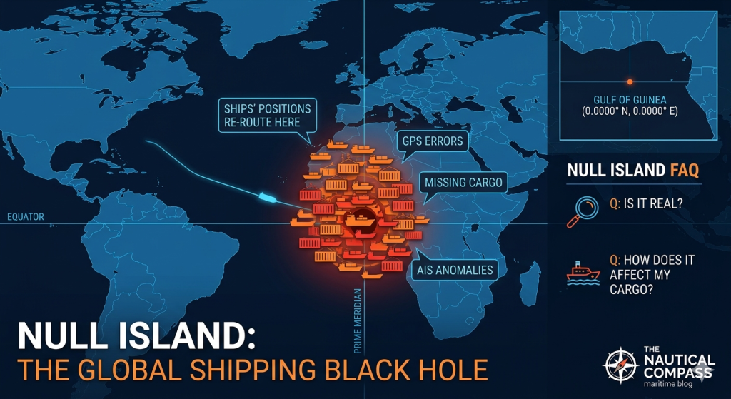
Geographically, Null Island is the point where the Equator (0° Latitude) meets the Prime Meridian (0° Longitude). Located in the Gulf of Guinea, it is the “Origin” (0,0) of the world’s most common geographic coordinate system, WGS84.
In the world of computer science, “Null” represents an absence of data. When a GPS sensor fails, a software script glitches, or a human forgets to enter coordinates into a shipping manifest, the system often defaults to “0”.
To a computer, 0 is not “nothing.” 0 is a specific coordinate. Consequently, every ship with a broken transponder, every container with an unmapped destination, and every port entry with a database error is instantly “teleported” to this single square meter of ocean.
The Maritime Connection: A High-Stakes Game of Hide and Seek
In an industry that moves 90\% of global trade, data accuracy isn’t a luxury—it’s the backbone of the global economy. Here is how Null Island wreaks havoc on the maritime world:
1. The AIS “Ghost Ship” Phenomenon
The Automatic Identification System (AIS) is the heartbeat of maritime safety. Ships broadcast their position to avoid collisions. However, if a ship’s GPS loses its lock or the software experiences a “null” event, the ship’s icon on tracking screens (like MarineTraffic or FleetMon) will suddenly jump from the English Channel to Null Island in a fraction of a second. These “ghost jumps” can trigger false alarms for piracy, search and rescue, or vessel loss.
2. The “Dark Fleet” and Sanctions Evasion
Null Island has become a convenient hiding spot. Vessels looking to hide their tracks—often those involved in illegal fishing or carrying sanctioned oil—may intentionally “spoof” their coordinates. While most spoofing is sophisticated, lazy actors or poorly configured equipment often dump the vessel’s location at (0,0). For maritime intelligence analysts, a sudden surge of activity at Null Island is often a red flag for illicit behavior elsewhere.
3. Supply Chain “Black Holes”
Imagine a logistics manager tracking 500 containers from Shanghai to Rotterdam. Suddenly, the dashboard shows three containers located in the middle of the South Atlantic. This isn’t a hijacking; it’s a geocoding error. Because the destination address couldn’t be parsed by the software, the system defaulted to 0,0. These “teleported” containers create massive ripples in supply chain visibility, leading to missed pickups and inventory “stock-outs.”
The Only Resident: The Soul Buoy
While “Null Island” is a digital fiction, the spot isn’t entirely empty. It is home to Station 13010, more affectionately known as the Soul Buoy.
As part of the PIRATA (Prediction and Research Moored Array in the Tropical Atlantic) system, this 3.8-meter-tall buoy is anchored to the seabed nearly 5 kilometers below. It measures wind speed, humidity, and temperature. It is the only physical witness to the millions of digital “ghost ships” that pass through its coordinates every single day.
Why We Can’t Just “Delete” Null Island
You might wonder: If we know (0,0) is usually an error, why don’t we just ignore it?
In the maritime industry, it’s not that simple. Sometimes, a ship is actually at or near (0,0). Ships sailing from Brazil to Europe or South Africa to the US pass through the Gulf of Guinea frequently. Simply filtering out all (0,0) data would create a “blind spot” in one of the world’s most active shipping lanes.
Instead, the industry has turned Null Island into a QA (Quality Assurance) trap. Analysts use it as a “misfit bin.” If a data point lands there, it’s a signal to the data engineers that something is broken in the pipeline—whether it’s a faulty sensor on a hull or a bug in the port’s API.
The Costs of a “Trip” to Null Island
| Impact Area | Consequences |
|---|---|
| Logistics | False delivery estimates and “lost” inventory alerts. |
| Safety | Interference with collision-avoidance algorithms. |
| Finance | Overstated insurance premiums due to “anomalous” vessel behavior. |
| Compliance | False positives for ships entering “prohibited” zones or crossing borders. |
Frequently Asked Questions (FAQ)
Q: Can I visit Null Island?
A: Yes, but bring a boat and a lot of supplies. There is no land. The nearest landmass is an islet off the coast of Ghana, about 570 km to the north. You will find nothing but the Soul Buoy and deep blue water.
Q: Is Null Island the only “error island”?
A: No! There are others. For example, if a programmer accidentally swaps Latitude and Longitude, ships might end up in the “Mirror Null Island” or other bizarre locations. However, (0,0) is by far the most common because it is the default value for most computer databases.
Q: Does Null Island affect GPS in my car?
A: Occasionally. If your phone’s mapping app fails to get a signal and doesn’t have a “fail-safe” UI, you might see your blue dot flicker to the coast of Africa for a split second before snapping back to your actual location.
Q: How do shipping companies fix this?
A: Through a process called Data Cleaning. Sophisticated maritime software uses “logic gates” to verify data. For example, if a ship was in New York 10 minutes ago and is suddenly at Null Island, the software knows the speed required (>50,000 \text{ knots}) is physically impossible and flags the data as an error.
Q: Why is it called “Null Island”?
A: The term was coined around 2011 by geospatial analysts. “Null” is the programming term for an undefined or empty value. Since the coordinates are 0,0, and it’s in the ocean, it became the “Island of Null.”
Conclusion: The Most Important Place That Isn’t There
Null Island is a permanent reminder of the gap between our physical world and our digital maps. In the shipping industry, where precision is measured in centimeters and seconds, (0,0) serves as a vital red flag. It is the “trash can” of the global supply chain—a place where every mistake, glitch, and oversight is gathered in one place.
The next time you track a package and it seems to be taking a scenic route through the middle of the Atlantic, don’t panic. It’s just taking a quick vacation on Null Island.
Recent Comments